
500 Years of History Under Your Feet
Every stone you step on was placed by Inca hands five centuries ago. This is the story of how it was built, who walked it, and how it reached us.
More Than a Trekking Trail
When you walk the Inca Trail, you’re not simply trekking. You’re traveling a sacred pilgrimage route built more than 500 years ago by one of the most extraordinary civilizations in human history.
Every stone step, every retaining wall, every tunnel carved in rock was deliberately placed by Inca engineers and workers. And most amazing: after five centuries, earthquakes, tropical rain and millions of footsteps, the path is still there.
This is not just the story of a trekking route. It’s the story of an empire, an engineering feat, and a spiritual connection between man and mountain that has endured half a millennium.
What You’ll Learn in This Article
The Inca Empire and its road network Why and how the Inca Trail to Machu Picchu was built Who walked this route and for what purpose The archaeological sites of the route and their meaning The fall of the empire and abandonment of the trail The modern rediscovery The history of tourism and current protection
The Inca Empire: Historical Context
To understand the Inca Trail, we must first understand the empire that created it.
Tahuantinsuyo: The Empire of the Four Quarters
Aspect | Detail |
Name | Tahuantinsuyo (“The Four Regions Together”) |
Period | Approximately 1438-1533 AD |
Maximum extent | ~2 million km² (from Colombia to Chile) |
Population | 10-12 million people |
Capital | Cusco (Qosqo = “Navel of the World”) |
Language | Quechua (still spoken by 8+ million today) |
Ruler | Sapa Inca (“Only Inca”) |
Timeline of the Inca Empire
Date | Event |
~1200 AD | The Incas settle in Cusco valley as small tribe |
1438 | Pachacútec defeats the Chancas and begins imperial expansion |
1438-1471 | Reign of Pachacútec — construction of Machu Picchu and Inca Trail |
1471-1493 | Reign of Túpac Inca Yupanqui — maximum territorial expansion |
1493-1527 | Reign of Huayna Cápac — empire’s peak |
1527-1532 | Civil war between Huáscar and Atahualpa |
1532 | Arrival of Francisco Pizarro and Spanish conquistadors |
1533 | Capture and execution of Atahualpa — empire collapse |
1572 | Fall of Vilcabamba, last Inca stronghold |
The Inca Trail to Machu Picchu was built during Pachacútec’s reign, approximately between 1450 and 1470 AD.
Pachacútec: The Empire Builder
The ninth Sapa Inca, Pachacútec Inca Yupanqui (1438-1471), is considered the true founder of the empire and architect of its greatness.
His achievements include:
Achievement | Significance |
Transformation of Cusco | Redesigned capital in shape of puma |
Road system | Expanded road network to imperial scale |
Machu Picchu | Ordered its construction as his royal estate |
The Inca Trail | Created sacred pilgrimage route |
Empire organization | Established Inca administrative system |
Military conquests | Expanded empire from Ecuador to Bolivia |
The name “Pachacútec” means “He who transforms the world” or “Earth shaker.” And did he ever.
The Qhapaq Ñan: The Inca Road Network
The Inca Trail to Machu Picchu is just a small part of something much larger.
The Largest Network in the Ancient World
The Incas built the most extensive road network of any ancient civilization, surpassing even the Romans in proportion to their existence time.
Aspect | Detail |
Name | Qhapaq Ñan (“Royal Road” or “Road of the Powerful”) |
Total extent | More than 30,000 km |
Current countries it crosses | Colombia, Ecuador, Peru, Bolivia, Chile, Argentina |
Recognition | UNESCO World Heritage Site (2014) |
Average width | 1-4 meters (up to 8 meters in main sections) |
Construction time | Less than 100 years |
Comparison with Other Civilizations
Civilization | Road Network | Construction Time |
Roman Empire | ~80,000 km | ~500 years |
Inca Empire | ~30,000 km | ~100 years |
Persian Empire | ~2,500 km | ~200 years |
The Incas built their road network approximately 5 times faster than the Romans proportionally.
Structure of the Qhapaq Ñan
The network had two main routes:
The Inca Trail to Machu Picchu is a secondary route branching from the main highland road, designed specifically to access Pachacútec’s royal estate.
Engineering of Inca Roads
The Incas had no wheel or pack animals (only llamas for light loads). However, they built roads that have lasted 500 years.
Construction techniques:
Technique | Application |
Stone steps | On steep slopes, carved into rock |
Retaining walls | To stabilize hillsides and prevent landslides |
Drainage | Channels to divert rainwater |
Suspension bridges | Of plant fibers, crossed rivers and ravines |
Tunnels | Carved in rock when easier than going around |
Raised causeways | In swampy or floodable areas |
Stone paving | In main and ceremonial sections |
The Chasquis: Empire Messengers
Inca roads weren’t just for walking. They were the empire’s communication network.
Aspect | Detail |
Who they were | Professional messengers trained from youth |
How they worked | Relay system every 6-9 km |
Speed | A message could travel 240 km in one day |
What they carried | Quipus (knotted strings = information), oral messages, small objects |
Cusco to Quito | ~2,000 km in 5-7 days |
Fascinating fact: The chasqui system was so efficient that the Sapa Inca in Cusco could eat fresh fish from the Pacific (300+ km away) brought by chasqui relays in less than 24 hours.
The Construction of the Inca Trail to Machu Picchu
Now let’s enter the specific history of the route you’ll walk.
Why Was It Built?
Machu Picchu wasn’t a common city. It was Pachacútec’s royal estate (llaqta), a combination of:
Function | Description |
Retreat palace | Sapa Inca’s rest residence |
Ceremonial center | Place for rituals and astronomical observations |
Agricultural center | Experimental terraces for crops |
Symbol of power | Demonstration of Inca capacity to dominate nature |
Sacred place | Connection point between earthly and spiritual world |
The Inca Trail was built as the ceremonial access route to this sacred place. It wasn’t simply the most practical road — it was a designed pilgrimage experience.
Intentional Route Design
Inca architects designed the path to create a progressive spiritual experience:
Stage | Experience | Purpose |
Start (Valley) | Leave daily world behind | Transition |
Climb to Warmiwañusca | Extreme effort, “symbolic death” | Purification |
Descent and ascent | Pass through minor ceremonial sites | Spiritual preparation |
Cloud forest | Mystical environment, mist, nature | Liminality |
Intipunku (Sun Gate) | First view of Machu Picchu | Revelation |
Arrival | Entry to sacred precinct | Rebirth |
Warmiwañusca pass (4,215 m) has a name meaning “Dead Woman” or “Dead Woman’s Pass.” Some historians believe it represented symbolic death of the pilgrim before being “reborn” at Machu Picchu.
How Was It Built?
Labor:
Aspect | Detail |
Work system | Mit’a (obligatory rotating work for state) |
Workers | Thousands of men from different empire regions |
Specialists | Elite architects, engineers, stonemasons |
Estimated duration | 10-20 years for road and Machu Picchu |
Specific techniques on this route:
Section | Technique |
Day 2 steps | Carved directly into bedrock |
Tunnel near Phuyupatamarca | Drilled through mountain |
Intipata terraces | Retaining walls 6+ meters |
Road over precipices | Path carved in vertical walls |
Bridges (original) | Braided ichu (Andean grass) fibers |
The Archaeological Sites of the Route
The Inca Trail doesn’t just connect points — the sites along it are integral to the experience.
Llactapata (Km 6)
Aspect | Detail |
Name means | “Town on the height” |
Function | Agricultural and administrative center |
Features | Terraces, warehouses, residential structures |
Alignment | Direct view to Machu Picchu (possible astronomical connection) |
Runkurakay (Km 20)
Aspect | Detail |
Name means | “Egg-shaped house” or “House in ruins” |
Function | Tambo (rest station) and watchtower |
Features | Unusual circular structure, panoramic view |
Location | 3,760 m, strategic control point |
Sayacmarca (Km 22)
Aspect | Detail |
Name means | “Inaccessible town” or “Dominant town” |
Function | Ceremonial and residential center |
Features | Built on precipice, steep access stairway |
Particularity | Only accessible by narrow stairs — highly defensive |
Phuyupatamarca (Km 28)
Aspect | Detail |
Name means | “Town above the clouds” |
Function | Ceremonial center emphasizing water cult |
Features | 6 ceremonial baths/fountains, terraces |
Location | 3,600 m, frequently above cloud line |
View | Spectacular panorama of valley and snow peaks |
Intipata (Km 30)
Aspect | Detail |
Name means | “Place of the Sun” or “Terraces of the Sun” |
Function | Extensive agricultural center |
Features | More than 100 agricultural terraces |
Theory | Possible food production area for Machu Picchu |
Wiñay Wayna (Km 37)
Aspect | Detail |
Name means | “Forever young” (name of local orchid) |
Function | Important ceremonial and agricultural center |
Features | Spectacular terraces, fountains, residential structures |
Size | Largest site before Machu Picchu |
Theory | Possible final preparation place before entering Machu Picchu |
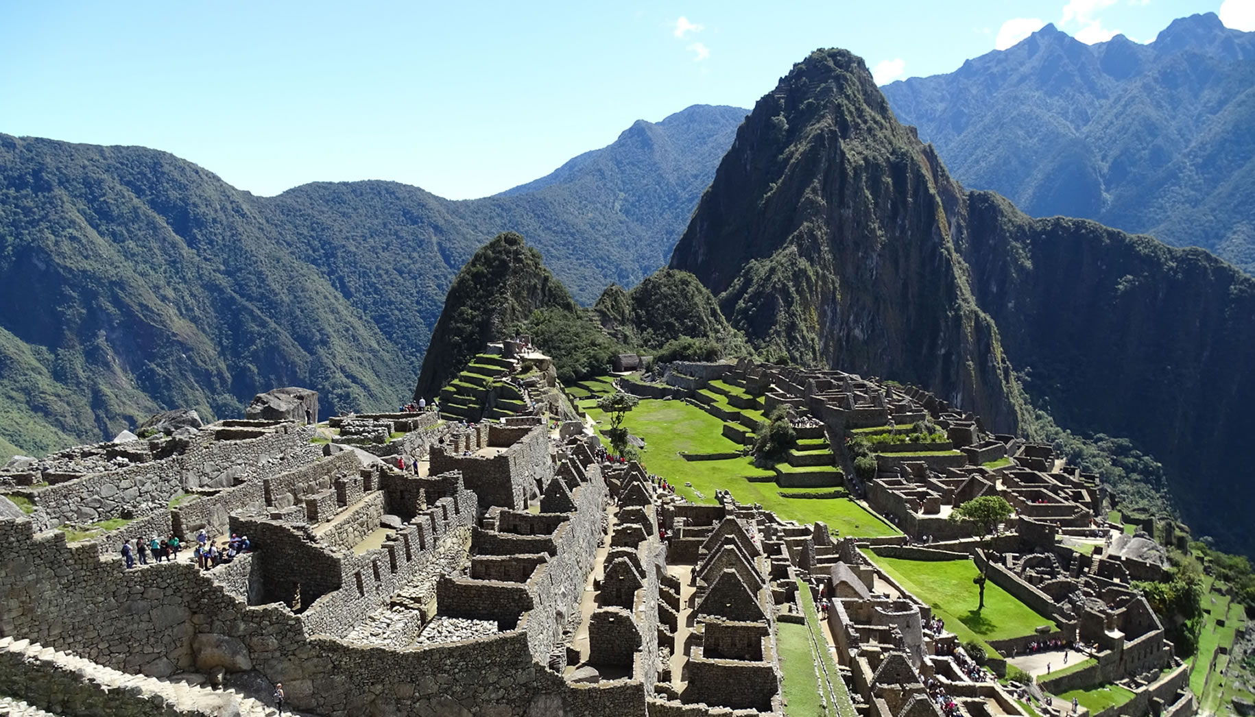
Intipunku – The Sun Gate (Km 43)
Aspect | Detail |
Name means | “Sun Gate” |
Function | Ceremonial entrance to Machu Picchu |
Features | Control structure with trapezoidal windows |
Solar alignment | Winter solstice sun (June 21) enters through windows |
Experience | First view of Machu Picchu for pilgrims |
Who Walked the Inca Trail?
The Inca Trail to Machu Picchu wasn’t for everyone. It was a restricted route for specific people.
The Privileged Who Used This Route
Group | Purpose |
The Sapa Inca | Trips to his royal estate, ceremonies |
Royal family | Accompanied Inca or visited independently |
Elite priests | Rituals at Machu Picchu and route sites |
Nobles and administrators | By Inca’s invitation |
The Acllas (Virgins of the Sun) | Women dedicated to solar cult, lived at Machu Picchu |
Chasquis | Messengers carrying official communications |
Specialized workers | During construction and maintenance |
Common people of the empire probably never set foot on this path. It was a sacred route reserved for the elite.
What Traveling Was Like in Inca Times
Aspect | Inca Reality |
Speed | 20-30 km per day walking |
Accommodation | Tambos (stations) every 15-25 km |
Food | Provided by state at tambos |
Security | Extremely high — crime almost nonexistent on imperial roads |
Personal load | Carried by porters or llamas |
The Sapa Inca | Traveled in litter carried by special porters |
Ceremonies on the Route
The journey wasn’t just transportation — each site had specific rituals:
Site | Probable Ceremony |
Warmiwañusca | Offerings to apus (mountain spirits) |
Runkurakay | Vigilance and protection rituals |
Phuyupatamarca | Ritual purification in water fountains |
Wiñay Wayna | Final preparation, possible fasting |
Intipunku | Ritual entry at solstice sunrise |
The Fall of the Empire and Abandonment
Everything changed in 1532.
The Arrival of the Spanish
Date | Event |
1532 | Francisco Pizarro arrives with ~180 men |
November 1532 | Capture of Atahualpa in Cajamarca |
1533 | Execution of Atahualpa, collapse of imperial structure |
1533-1536 | Conquest of Cusco and initial resistance |
1536-1572 | Inca resistance from Vilcabamba |
1572 | Fall of Vilcabamba, end of organized resistance |
What Happened to Machu Picchu and the Inca Trail?
The amazing part: The Spanish never found Machu Picchu.
Theory | Explanation |
Early abandonment | Machu Picchu may have been abandoned even before conquest, during Inca civil war (1527-1532) |
Kept secret | Local inhabitants knew of its existence but didn’t reveal to Spanish |
Remote location | Far from main routes, difficult to find without guide |
Lack of visible gold | Spanish sought gold; Machu Picchu didn’t have it in superficial abundance |
The Inca Trail was progressively abandoned as:
400 Years of Oblivion
Between ~1550 and 1911, the Inca Trail and Machu Picchu existed in historical limbo:
Period | Situation |
1550-1800 | Known by local Quechua settlers, ignored by colonizers |
1800-1900 | Some mentions in local records, but no formal exploration |
1860s-1870s | Explorers like Antonio Raimondi and Charles Wiener mention rumors of lost cities |
1902 | Local farmer Agustín Lizárraga carves his name at Machu Picchu |
1911 | Hiram Bingham “discovers” Machu Picchu for Western world |
The Modern Rediscovery
The story of Machu Picchu’s “discovery” is fascinating and controversial.
Hiram Bingham III: The “Discoverer”
Fact | Detail |
Who he was | American historian and explorer from Yale |
Date | July 24, 1911 |
Original purpose | Was searching for Vilcabamba, last Inca capital |
How he arrived | Guided by local peasant Melchor Arteaga |
First contact | Quechua families living among ruins |
What he found | Machu Picchu covered with vegetation but structurally intact |
Did He Really “Discover” Machu Picchu?
The controversy:
Argument | Detail |
For Bingham | Was first to document it scientifically and make it known to world |
Against | Local inhabitants always knew of its existence |
Evidence | Agustín Lizárraga had written his name on ruins in 1902, 9 years before |
Other visits | Records of previous undocumented visits |
Current perspective: Bingham didn’t “discover” Machu Picchu — he revealed it to the Western academic world. Discovery credit belongs to local settlers who knew of it all along.
Bingham’s Expeditions
Expedition | Year | Achievements |
First | 1911 | Initial documentation of Machu Picchu |
Second | 1912 | Extensive clearing, detailed photography, excavations |
Third | 1914-1915 | Exploration of Inca Trail, route mapping |
Bingham also “discovered” the Inca Trail during these expeditions, following the route from Ollantaytambo and documenting archaeological sites along the way.
The Artifacts Controversy
Fact | Detail |
Artifacts removed | Bingham sent ~46,000 pieces to Yale University |
Original agreement | 18-month loan for study |
Reality | Yale kept pieces for almost 100 years |
Return | Between 2011-2012, Yale returned most to Peru |
Current location | Machu Picchu Museum – Casa Concha, Cusco |
History of Tourism on the Inca Trail
The Inca Trail wasn’t always a tourist attraction.
Tourism Timeline
Decade | Development |
1910s-1940s | Only explorers and academics |
1950s | First adventurous tourists, no infrastructure |
1960s | Backpacker interest begins, informal route |
1970s | Growth of South American “Gringo Trail” |
1980s | First agencies organize treks, still unregulated |
1990s | Mass tourism begins, degradation problems |
2001 | Implementation of 500 people/day limit |
2010s | Stricter regulations, sustainability focus |
2020 | Closure due to COVID-19 pandemic |
2021-present | Reopening with protocols, conscious tourism |
The Problem of the 90s
Before regulations:
Problem | Impact |
No visitor limit | Days with 2,000+ people on route |
No agency regulation | Anyone could operate |
Exploited porters | Loads of 40+ kg, miserable wages, no protection |
Environmental damage | Trash, erosion, damage to ruins |
Trail degradation | Sections damaged by excess traffic |
The 2001 Reforms
The Peruvian government implemented radical changes:
Reform | Detail |
500/day limit | Includes tourists + staff |
Only authorized agencies | Registration and license mandatory |
Nominative permits | Each person identified by passport |
Porter regulation | Weight limit (25 kg), minimum wage |
February closure | Mandatory annual maintenance |
Certified guides | Mandatory licensed guide |
Evolution of Porter Protection
Year | Improvement |
2001 | First weight limit (25 kg) |
2003 | Porter Law (Law 27607) |
2005 | Mandatory weight inspections |
2010s | Stronger porter unions |
2015+ | Ethical agencies implement superior standards |
Today | Porter Promise and similar certifications |
International Recognition
Year | Recognition |
1983 | Machu Picchu: UNESCO World Heritage Site |
1983 | Machu Picchu Historical Sanctuary: UNESCO Natural Heritage |
2007 | Machu Picchu: New Wonder of the World |
2014 | Qhapaq Ñan (Inca road network): UNESCO World Heritage Site |
Mysteries We Still Haven’t Solved
Despite more than 100 years of study, questions remain without definitive answers.
Why Was Machu Picchu Abandoned?
Theory | Argument |
Smallpox | Epidemic may have killed inhabitants before conquest |
Civil war | Abandoned during Huáscar-Atahualpa conflict (1527-1532) |
Death of Pachacútec | Without its creator, estate lost importance |
Strategic secret | Deliberately abandoned to protect from Spanish |
System collapse | Without Inca state, no resources to maintain it |
There’s no consensus. It was probably a combination of factors.
What Was Machu Picchu’s Real Function?
Theory | Proponent | Evidence |
Pachacútec’s royal estate | Current dominant theory | Colonial documents, elite architecture |
Astronomical center | Dearborn, White | Precise solar alignments |
Last Inca refuge | Bingham (original) | Discarded — not Vilcabamba |
University/learning center | Popular theories | No strong evidence |
Ceremonial center | Multiple | Temples, Intihuatana, ritual fountains |
Probable answer: It was all that — a royal estate that also served ceremonial, astronomical and administrative functions.
How Did They Transport the Stones?
Machu Picchu has stones of more than 50 tons perfectly placed.
Theory | Method |
Ramps and levers | Similar to Egyptian construction |
Wooden rollers | Logs to slide |
Organized brute force | Thousands of coordinated workers |
Local stones | Many stones from same mountain |
The Incas had no wheel or heavy pack animals. The answer is a combination of brilliant engineering, massive organization and exploitation of local terrain.
What Do the Astronomical Alignments Mean?
The Intihuatana and other Machu Picchu elements have precise solar alignments:
Alignment | Event |
Intipunku | Winter solstice sun (June 21) |
Intihuatana | Equinoxes (March 21, September 23) |
Temple of the Sun | Winter solstice, light enters through specific window |
Window of Three Windows | Possible alignment with Pleiades |
The Incas were sophisticated astronomers who used these alignments for agricultural and ceremonial calendars. But the complete meaning of all alignments continues to be studied.
The Inca Trail Today
500 years after its construction, the Inca Trail is still alive.
Conservation Status
Aspect | State |
Original trail | 60-70% preserved in original form |
Restored sections | 20-30% rebuilt with traditional techniques |
Archaeological sites | Well preserved, ongoing restoration |
Maintenance | Annual February closure, permanent teams |
Conservation Challenges
Challenge | Response |
Footstep erosion | Visitor limit, alternative paths in fragile sections |
Rain and landslides | Retaining walls, improved drainage |
Invasive vegetation | Constant clearing |
Climate change | Monitoring, practice adaptation |
Tourism | Strict regulations, visitor education |
The Future of the Inca Trail
Initiative | Objective |
Sustainable tourism | Balance access with conservation |
Monitoring technology | Drones, sensors to detect damage |
Community participation | Local communities as guardians |
Ongoing research | New discoveries, better understanding |
Education | That every visitor understands the value of what they walk on |
Your Role in This History
When you walk the Inca Trail, you join a 500-year history.
Who Have Walked Before You
Era | Who |
1450-1550 | Pachacútec, his family, priests, nobles, acllas |
1550-1900 | Quechua peasants, occasional explorers |
1911-1950 | Bingham, academics, first adventurers |
1950-2000 | Backpackers, first organized tourists |
2001-today | More than 1 million people from around the world |
Now you’ll be part of that list.
Your Responsibility
When walking the Inca Trail, you have responsibilities:
Responsibility | How to Fulfill It |
Preserve the trail | Don’t leave path, don’t damage structures |
Respect history | Understand what you walk on, not just walk |
Support communities | Choose ethical agencies with porters |
Take only memories | Don’t take stones, plants, artifacts |
Leave only footprints | Don’t leave trash, use designated bathrooms |
Share the story | Tell others about cultural importance |
Walk the History
Every stone of the Inca Trail has a story. Every step was placed by hands that built an empire. Every archaeological site was the scene of ceremonies connecting the Incas with the cosmos.
When you walk the Inca Trail, you’re not doing tourism. You’re participating in a 500-year history.
Are you ready to be part of it?
Your Next Steps
We can help you find alternative Inca Trail dates.
📧 Email: info@inca-trail.pe
📱 WhatsApp: +51 921 333 639